BedMachine Greenland v4
Since 2010, we have been working on a self-consistent dataset of the Greenland Ice Sheet based on the conservation of mass that is now freely available at NSIDC. The new version (v4) now includes ocean bathymetry.
Description
The data are in one single file in NetCDF format (2.5 Gb) and all heights are in meters above mean sea level (the geoid used is provided in the NetCDF file). All the data use the same 150 m-resolution grid although the “true” resolution of the bedrock topography and ice thickness is 400 m. This dataset uses data from 1993 to 2016 and has a nominal date of 2007 (same as the GIMP DEM).
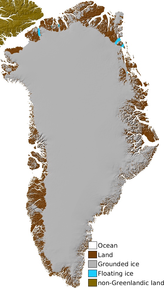 | Greenland mask The ice/land/ocean masks are from Howat et al. 2014 (Greenland Ice Mapping Project), and the floating ice is derived from InSAR grounding lines (pers. comm.). 0 = ocean, 1 = ice-free land, 2 = grounded ice, 3 = floating ice | 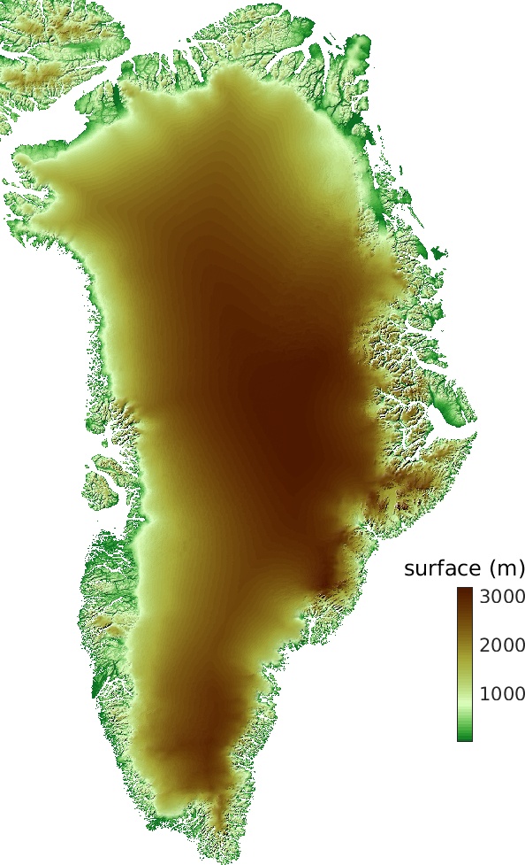 | Surface elevation The surface dem is from Howat et al. 2014 (Greenland Ice Mapping Project). |
 | Source Method used to calculate ice thickness: 0 = none, 1 = gimpdem, 2 = Mass conservation, 3 = synthetic, 4 = interpolation, 5 = hydrostatic equilibrium, 6=kriging, 7 = RTopo-2, 8 = gravity, 10+ = bathymetry data | 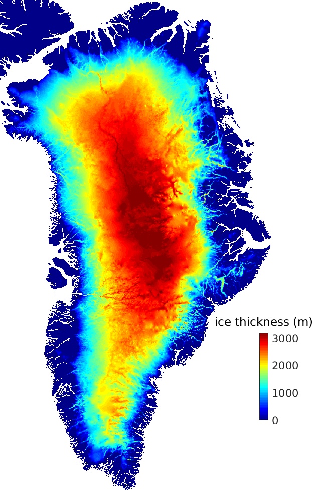 | Ice thickness The ice thickness is inferred using mass conservation along the peryphery of the ice sheet and ordinary kriging in the interior. |
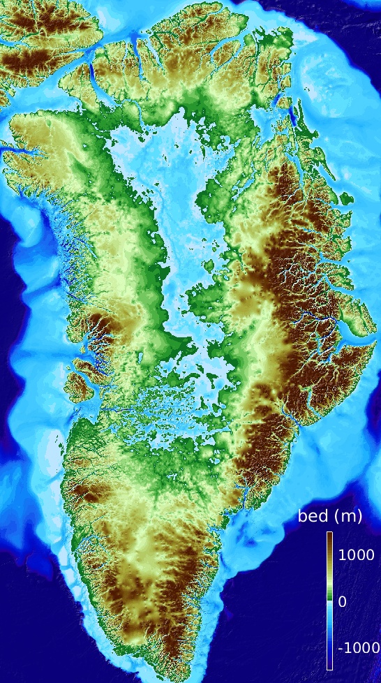 | Bed topography The bed elevation is calculated by subtracting the ice thickness from the surface elevation data. |  | Error map Ice thickness and bed topography error. |
For the hydrostatic equilibrium calculation, we used a density of ice ρice=917 kg/m3 and an ocean water density of ρocean=1023 kg/m3.
As any model output, there are errors in these maps (there is an estimate included in the dataset). Feedback is more than welcome.
Citation
- Morlighem M. et al., (2017), BedMachine v3: Complete bed topography and ocean bathymetry mapping of Greenland from multi-beam echo sounding combined with mass conservation, Geophys. Res. Lett., 44, doi:10.1002/2017GL074954, http://onlinelibrary.wiley.com/doi/10.1002/2017GL074954/full
Projection
The projection is Polar Stereographic North (70ºN, 45ºW), which corresponds to ESPG 3413.
Reading with MATLAB
filename = 'BedMachineGreenland-2021-01-26.nc';
x = ncread(filename,'x');
y = ncread(filename,'y');
bed = ncread(filename,'bed')'; %Do not forget to transpose (MATLAB is column oriented)
%Display bed elevation
imagesc(x,y,bed); axis xy equal; caxis([-500 1800]);
MATLAB now has an extensive library for NetCDF files.
Bathymetry data source
The source field shows where bathymetry data have been used when it is greater than 10:
- 10 MaxSea (contact: Martin Jakobson and Karl Zinglersen)
- 11 OLEX (contact: Martin Jakobson)
- 12 Dowdeswell (contact: David Dowdeswell)
- 13 Catannia (contact: Ginny Catannia)
- 14 Rysgaard 2 (contact: Søren Rysgaard)
- 15 Rysgaard 3 (contact: Søren Rysgaard)
- 16 Chauché Lille (contact: Nolwenn Chauché)
- 17 Chauché Lille2 (contact: Nolwenn Chauché)
- 18 Chauché Silarlleq (contact: Nolwenn Chauché)
- 19 Upernavik data (contact: Camilla Snowman Andresen, Andreas Peter Ahlstrøm and Karl Zinglersen)
- 20 Holland et al. (Jakobshavn) (contact: David Holland)
- 21 Fiamma (contact: Fiamma Straneo )
- 22 Fiamma2 (contact: Fiamma Straneo)
- 23 Sugiyama (contact: Shin Sugiyama)
- 24 Rignot2008 (contact: Eric Rignot)
- 25 Rignot2012-2013 (contact: Eric Rignot)
- 26 Stevens (contact: Laura Stevens)
- 27 Motyka (contact: Roman Motyka)
- 28 JR105 (Sutherland and Pickart 2008)
- 29 Kjeldsen (contact: Wilhelm Weinrebe and KK Kjeldsen)
- 30 Weinrebe 2007 (contact: Wilhelm Weinrebe)
- 31 Rysgaard (contact: Søren Rysgaard)
- 32 O Cofaigh Dowdeswell 2009 (contact: O’Cofaigh and Dowdeswell 2009)
- 33 ORP (contact: Eric Rignot)
- 34 Arndt et al. 2015 (contact: Jan-Erik Arndt)
- 35 PetermannTransect (contact: Martin Jakobsson)
- 36 Jakobsson Petermann (Mix et al. 2015)
- 37 Oden 2015 (Freire et al. 2015)
- 38 Slabon et al. 2016 (contact: Boris Dorschel)
- 39 OMG West (contact: Eric Rignot)
- 40 OMG West (contact: Eric Rignot)
- 41 OMG Southeast (contact: Eric Rignot)
- 42 Gravity inversion Southeast Greenland An et al. 2019 (contact: Lu An)
- 43 OMG Southeast campaign 2 (contact: Eric Rignot)
- 44 OMG 2019 campaign (contact: Eric Rignot)
- 45 OMG 2020 campaign, Rignot et al 2021 (contact: Eric Rignot)
- 46 Jakobsson et al. 2020 Nature Earth and Env. Comm. (contact: Martin Jakobsson)
- 47 Bathymetry data collected by the Bathymetry group of the Alfred Wegener Institute Helmholtz Centre for Polar and Marine Research, Bremerhaven, Germany (contact: Simon Dreutter)
Converting heights to WGS84
All heights are referenced to mean sea level (using the geoid EIGEN-6C4). To convert the heights to heights referenced to the WGS84 ellipsoid, simply add the geoid height:
\(z_{ellipsoid}=z_{geoid} + geoid\)
Extending coverage further
Modelers interested in extending their models outside of the area covered by BedMachine can use IBCAO v4 for the area that lie outside of the dataset Since BedMachine v4 is based on these datasets 50 km away from the coast, the transition will be seamless.
Disclaimer
The ice thickness and bed topography are model outputs and are not free of error (especially in regions where ice thickness measurements are sparse). This dataset is a work in progress and we encourage users to send us feedback so that we keep improving it.
Acknowledgements and References
This project is performed at Dartmouth College and the University of California Irvine under a contract with the National Aeronautics and Space Administration (IceBridge Research #NNX12AB86G, Cryospheric Science #NNX15AD55G) and the National Science Foundation (ARCSS #1504230).
The ice thickness data are from:
- Gogineni, P. CReSIS RDS Data (from 1993 to 2013); freely available here http://data.cresis.ku.edu/.
- Nixdorf, U., D. Steinhage, U. Meyer, L. Hempel, M. Jenett, P. Wachs, and H. Miller (1999), The newly developed airborne radio-echo sounding system of the AWI as a glaciological tool, Ann. Glaciol., 29, 231–238, doi:10.3189/172756499781821346
- H. Thomsen, et al., The Nioghalvfjerdsfjorden glacier project, north-east Greenland: a study of ice sheet response to climatic change, Geol. Surv. Greenland Bull. 179, 95 (1997). (79North region)
- E. L. Christensen, et al., A low-cost glacier-mapping system, J. Glaciol. 46, 531 (2000). (79North region)
- Lindbäck, K., Pettersson, R., Doyle, S. H., Helanow, C., Jansson, P., Kristensen, S. S., Stenseng, L., Forsberg, R., and Hubbard, A. L.: High-resolution ice thickness and bed topography of a land-terminating section of the Greenland Ice Sheet, Earth Syst. Sci. Data, 6, 331-338, doi:10.5194/essd-6-331-2014, 2014. Available upon request to the author (Russell Region)
- Peters, M., D. Blankenship, and D. Morse (2005), Analysis techniques for coherent air- borne radar sounding: Application to West Antarctic ice streams, J. Geophys. Res., 110(B6), doi:10.1029/2004JB003222.
- Peters, M. E., D. D. Blankenship, S. P. Carter, S. D. Kempf, D. A. Young, and J. W. Holt (2007), Along-track focusing of airborne radar sounding data from West Antarctica for improving basal reflection analysis and layer detection, IEEE Trans. Geosc. and Rem.Sens., 45(9), 2725–2736, doi:10.1109/TGRS.2007.897416.
- Raney, K. (2010), IceBridge PARIS L2 ice thickness. version 1.0, doi: 10.5067/OMEAKG6GIJNB, boulder, Colorado USA: NASA DAAC at the National Snow and Ice Data Center
The bathymetry data are from:
- Bendtsen, J., J. Mortensen, K. Lennert, J. K.Ehn, W. Boone, V. Galindo, Y. Hu, I. A. Dmitrenko, S. A. Kirillov, K. K. Kjeldsen, Y. Kristoffersen, D. G.Barber, and S. Rysgaard. 2017. Sea ice breakup and marine melt of a retreating tidewater outlet glacier in northeast Greenland (81°N), Scientific Reports, 7(1), 4941, doi:10.1038/s41598.
- Chauché, N., A. Hubbard, J.-C. Gascard, J. E. Box, R. Bates, M. Koppes, A. Sole, P. Christoffersen, and H. Patton (2014), Ice-ocean interaction and calving front morphology at two west Greenland tidewater outlet glaciers, Cryosphere, 8(4), 1457–1468, doi:10.5194/tc-8-1457-2014
- Dowdeswell, J. A., K. A. Hogan, C. O’Cofaigh, E. M. G. Fugelli, J. Evans, and R. Noormets (2014), Late Quaternary ice flow in a West Greenland fjord and cross- shelf trough system: submarine landforms from Rink Isbrae to Uummannaq shelf and slope, Quat. Sci. Rev., 92(SI), 292–309.
- Dowdeswell, J. A., C. L. Batchelor, K. A. Hogan, and H. W. Schenke (2016), Atlas of Submarine Glacial Landforms: Modern, Quaternary and Ancient, vol. 46, chap. Nord- vestfjord: a major East Greenland fjord system, pp. 43–44, Geological Society, London, Memoirs, doi:10.1144/M46.40.
- Fried, M. J., G. A. Catania, T. C. Bartholomaus, D. Duncan, M. Davis, L. A. Stearns, J. Nash, E. Shroyer, and D. Sutherland. 2015. Distributed subglacial discharge drives significant submarine melt at a Greenland tidewater glacier, Geophys. R, 42(21), 9328– 9336, doi:10.1002/2015GL065806, 2015GL065806.
- Holland, D., R. Thomas, B. De Young, M. Ribergaard, and B. Lyberth (2008), Acceleration of Jakobshavn Isbrae triggered by warm subsurface ocean waters, Nat. Geosci., 1(10), 659–664, doi:10.1038/ngeo316.
- Kjeldsen, K. K., Weinrebe, R. W., Bendtsen, J., Bjørk, A. A., and Kjær, K. H.: Multibeam bathymetry and CTD measurements in two fjord systems in southeastern Greenland, Earth Syst. Sci. Data, 9, 589-600, https://doi.org/10.5194/essd-9-589-2017, 2017.
- Mix, A. C., M. Jakobsson, and the Petermann-2015 Scientific Party. 2015. Petermann-2015 Expedition Launches International Collaboration in Arctic Science, Tech. rep., Arctic Research Consortium of the United States.
- Motyka, R. J., R. Cassotto, M. Truffer, K. K. Kjeldsen, D. Van As, N. J. Korsgaard, M. Fahnestock, I. Howat, P. L. Langen, J. Mortensen, , K. Lennert, and S. Rys- gaard (2017), Asynchronous behavior of outlet glaciers feeding Godthåbsfjord (NuupKangerlua) and the triggering of Narsap Sermia’s retreat in SW Greenland, J. Glaciol., 63(238), 288308, doi:10.1017/jog.2016.138.
- Ó Cofaigh, C., J. A. Dowdeswell, A. E. Jennings, K. A. Hogan, A. Kilfeather, J. F. Hiem- stra, R. Noormets, J. Evans, D. J. McCarthy, J. T. Andrews, J. M. Lloyd, and M. Moros (2013), An extensive and dynamic ice sheet on the West Greenland shelf during the last glacial cycle, Geology, 41(2), 219–222.
- OMG Mission (2016), Bathymetry (sea floor depth) data from the ship-based bathymetry survey. Ver. 0.1. OMG SDS, CA, USA http://dx.doi.org/10.5067/OMGEV-BTYSS.
- Rignot, E., I. Fenty, Y. Xu, C. Cai, and C. Kemp (2015), Undercutting of marine-terminating glaciers in West Greenland, Geophys. Res. Lett., 42(14), 5909–5917, doi:10.1002/2015GL064236.
- Rignot, E., I. Fenty, Y. Xu, C. Cai, I. Velicogna, C. Ó Cofaigh, J. A. Dowdeswell, W. Weinrebe, G. Catania, and D. Duncan (2016), Bathymetry data reveal glaciers vulnerable to ice-ocean interaction in Uummannaq and Vaigat glacial fjords, west Greenland, Geophys. Res. Lett., 43(6), 2667–2674.
- Rysgaard, S., T. Vang, M. Stjernholm, B. Rasmussen, A. Windelin, and S. Kiilsholm. 2003. Physical conditions, carbon transport, and climate change impacts in a northeast Greenland fjord, Arctic Ant. Alp. Res., 35(3), 301–312, doi:10.1657/1523- 0430(2003)035[0301:PCCTAC]2.0.CO;2.
- Schaffer, J., R. Timmermann, J. E. Arndt, S. S. Kristensen, C. Mayer, M. Morlighem, and D. Steinhage (2016), A global, high-resolution data set of ice sheet topography, cavity geometry, and ocean bathymetry, Earth Syst. Sci. Data, 8(2), 543–557, doi:10.5194/essd- 8-543-2016.
- Schumann, K., D. Voelker, and W. R. Weinrebe (2012), Acoustic mapping of the Ilulissat Ice Fjord mouth, West Greenland, Quat. Sci. Rev., 40, 78–88.
- Slabon, P., B. Dorschel, W. Jokat, R. Myklebust, D. Hebbeln, and C. Gebhardt (2016), Greenland ice sheet retreat history in the northeast Baffin Bay based on high-resolution bathymetry, Quat. Sci. Rev., 154, 182 – 198, doi: http://doi.org/10.1016/j.quascirev.2016.10.022.
- Stevens, L. A., F. Straneo, S. B. Das, A. J. Plueddemann, A. L. Kukulya, and M. Morlighem (2016), Linking glacially modified waters to catchment-scale subglacial discharge using autonomous underwater vehicle observations, Cryosphere, 10(1), 417– 432, doi:10.5194/tc-10-417-2016.
- Straneo, F., D. A. Sutherland, D. Holland, C. Gladish, G. S. Hamilton, H. L. Johnson, E. Rignot, Y. Xu, and M. Koppes (2012), Characteristics of ocean waters reaching Greenland’s glaciers, Ann. Glaciol., 53(60, 2), 202–210.
- Straneo, F., G. S. Hamilton, L. A. Stearns, and D. A. Sutherland (2016), Connecting the Greenland Ice Sheet and the Ocean, a case study of Helheim Glacier and Sermilik Fjord, Oceanography, 29(4, SI), 34–45.
- Sutherland, D. A., and R. S. Pickart. 2008. The East Greenland Coastal Current: Structure, variability, and forcing, Prog. Oceanogr., 78(1), 58–77, doi: 10.1016/j.pocean.2007.09.006.
- Sutherland, D. A., F. Straneo, and R. S. Pickart (2014), Characteristics and dynamics of two major Greenland glacial fjords, J. Geophys. Res. – Oceans, 119(6), 3767–3791.
- Thomsen, H., et al. 1997. The Nioghalvfjerdsfjorden glacier project, north-east Greenland: a study of ice sheet response to climatic change, Geology of Greenland Survey Bulletin, 179:95.
- Weinrebe, R. W., A. KuijpKui, I. Klaucke, and M. Fink (2009), Multibeam Bathymetry Surveys in Fjords and Coastal Areas of West-Greenland, in Eos Trans. AGU, 90(52), Fall Meet. Suppl., Abstract OS21A1152.
- Single beam data from Olex (www.olex.no) and crowd sourced data from fishing and recreational vessels (MaxSea).
The surface velocity data used by MC are from:
- Mouginot, J., E. Rignot, B. Scheuchl, and R. Millan (2017), Comprehensive Annual Ice Sheet Velocity Mapping Using Landsat-8, Sentinel-1, and RADARSAT-2 Data, Remote Sens., 9(4), doi:10.3390/rs9040364. (Available upon request to the authors)
The surface mass balance is from RACMO 2.3 1 km:
- Noël, B., W. J. van de Berg, H. Machguth, S. Lhermitte, I. Howat, X. Fettweis, and M. R. van den Broeke (2016), A daily, 1 km resolution data set of downscaled Greenland ice sheet surface mass balance (1958–2015), Cryosphere, 10(5), 2361–2377, doi:10.5194/tc-10-2361-2016. (Available upon request to the authors)
Ice thickening rate is from SPOT dem differencing:
- Khan, S. A., K. H. Kjaer, M. Bevis, J. L. Bamber, J. Wahr, K. K. Kjeldsen, A. A. Bjork, N. J. Korsgaard, L. A. Stearns, M. R. van den Broeke, L. Liu, N. K. Larsen, and I. S. Muresan (2014), Sustained mass loss of the northeast Greenland ice sheet triggered by regional warming, Nat. Clim. Change, 4(4), 292–299, doi:10.1038/nclimate2161.
- Korona, J., E. Berthier, M. Bernard, F. Rémy, and E. Thouvenot (2009), SPIRIT. SPOT 5 stereoscopic survey of Polar Ice: Reference Images and Topographies during the fourth International Polar Year (2007–2009) , ISPRS J. Photogramm. Remote Sens., 64(2), 204– 212, doi:http://doi.org/10.1016/j.isprsjprs.2008.10.005.
The surface topography map is from:
- Howat, I.M., A. Negrete, B.E. Smith, 2014, The Greenland Ice Mapping Project (GIMP) land classification and surface elevation datasets, The Cryosphere, 8, 1509-1518, doi:10.5194/tc-8-1509-2014; freely available here http://bprc.osu.edu/GDG/gimpdem.php
The mask is derived from:
- Howat, I.M., A. Negrete, B.E. Smith, 2014, The Greenland Ice Mapping Project (GIMP) land classification and surface elevation datasets, The Cryosphere, 8, 1509-1518, doi:10.5194/tc-8-1509-2014; freely available here http://bprc.osu.edu/GDG/icemask.php